Maps
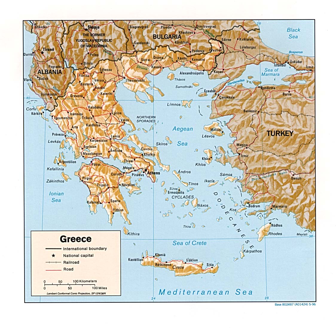
The shaded relief map of Greece, is exceptionally detailed but very large! This one might take a while to download.
As does Cultural map of Hellas by the Hellenic ministry of culture.
The Ancient Greece Map provides a concise but highly detailed map of mainland Greece and Asia Minor.
Greece in the Bronze Age displays the three distinctive civilizations Cycladic, Minoan and Mycenaean that developed around the Aegean in the third and second millenia B. C. E.
The Map of Bronze age Greece ( 3200-1150 BCE) allows the viewer to zoom on a an aerial photo with overlay that identifies the location of the major Bronze Age sites. While the Reconstruction of the political landscape in mainland southern Greece c.1400-1250 BC displays both the cities and states of the Bronze Age Greek world.
The Aegean World in the Bronze Age is also a very useful map of the Bronze Age world. As is the Aegean c. 1300-1200 BC, which details the relationship between the Mycenaean world and the Hittite Empire.
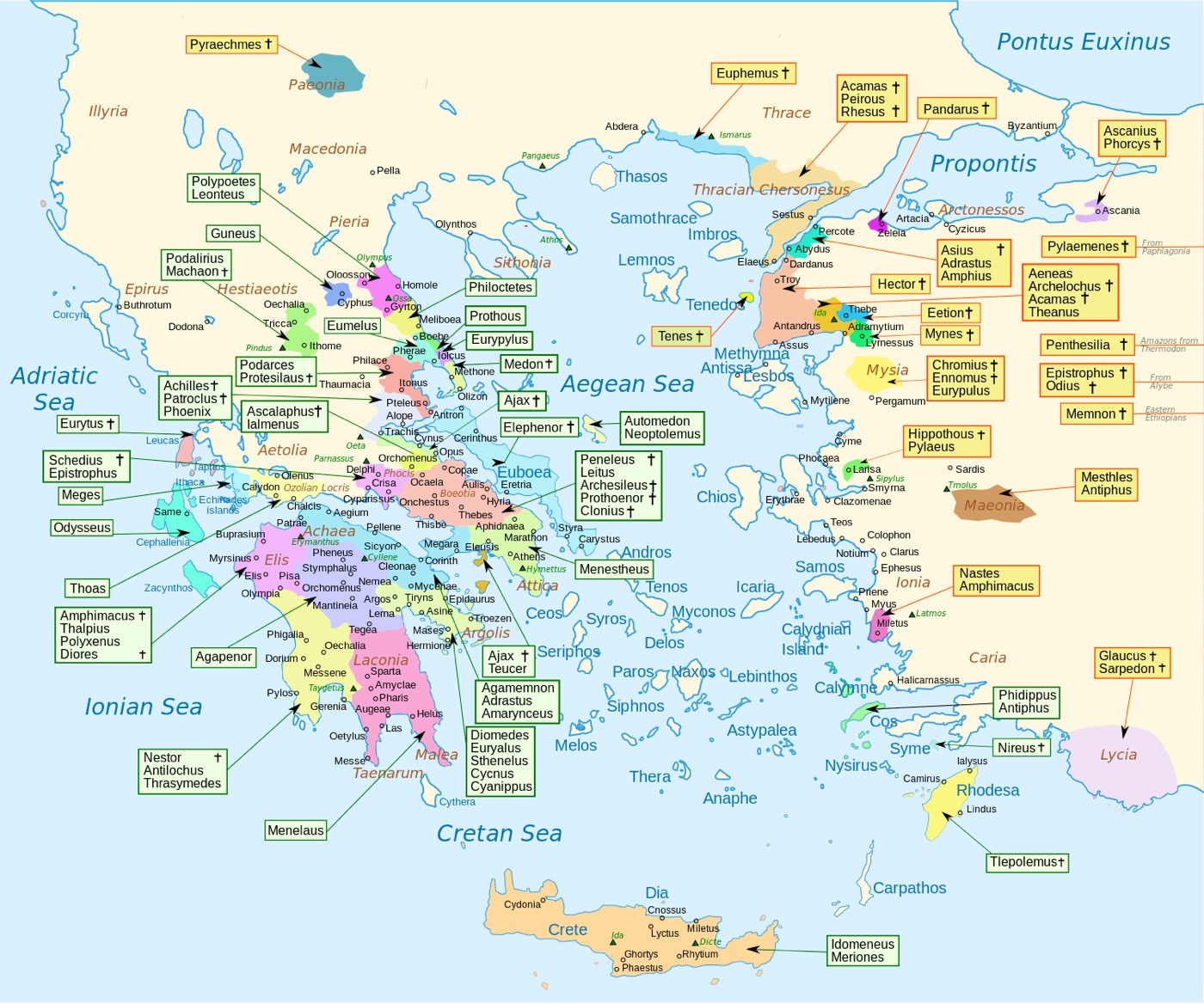
Students of Homer will find the Homeric geography map. quite useful. It displays the location of the sites that were home to a number of the characters in Homer’s account of the Trojan War.
Homeric Greece according to the Catalogue of Ships records where each of the Greek contingents to fight in the Trojan War originated from, thier leaders and and the number of ships they brought to Troy.
Also useful for those studying the Trojan War is the Map of the Trojan War and The Return (Nostoi) From Troy in Greece Epic Tradition.
Having trouble finding a specific site in Greece. Try the Mythological map of Heracles’s Tasks. To find the geographical place or scene in Greek history simply press on the name in the list below the map and a floating window will appear.
Greek cities and colonies of the Archaic Age shows the geographical extent of Greek civilization around the Aegean, as this map of Archaic Greece. While Greece in the Archaic Age displays the political structure of the region in 705-490 BCE.
Greeks and Phoenicians: colonization in the 10-6th century BCE enables you to observe the colonizing efforts of both the Greeks and their great rivals the Phoenicians, while Greek and Phoenician colonies shows how the colonizing movement progressed from the 1000 BCE to 323 BCE. See also Greek and Phoenecian colonization c. 900-500 BC.
Necessary for students of the Persian Wars are maps of the Persian Empire c. 500 BC and a map displaying the Territorial expansion of the Persian Empire up to c. 500 BC, as well as Greece and the Aegean c.479 B C .
Students of the Peloponnesian War will find the following maps quite useful. Greece and the Aegean c 448 BC., Greece during the Peloponnesian War I (Arkhidamian War), 431-421 BC, Greece during the Peloponnesian War II (Dekeleian War), 413-404 BC and Greece during the Spartan Hegemony c.404 BC .Follow the Route of Xenophon and his comrades as they march across the Persian Empire.
Greece under Theban Hegemony 371 BC- 362 BC displays Theban expansion under the brilliant generalship of Epminondas. Refer also to Greece during the Theban Hegemony c. 362 BC.
Greece and Aegean c. 336 BC following the conquests of Philip II.
Macedon and Alexander’s conquest show not only the extent of his empire but the routes followed by Alexander and his lieutenants.
Students interested in the Hellenistic World will find the following maps quite useful:
the Hellenistic World after the Breakup of Alexander’s Empire 310 B.C.,
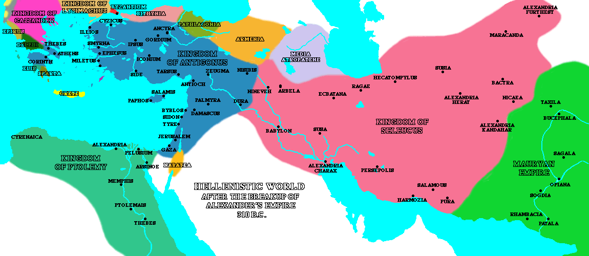
Alexander’s heirs in 301 BC (before the battle of Ipsos),
the Hellenistic World after the Death of Antigonus 300 B.C.,
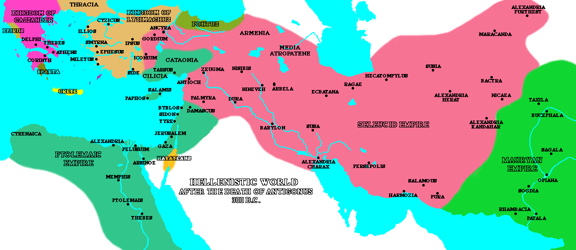
the Mediterranean World: During the Decline of the Hellenistic Kingdoms,
and the Rise of Rome 270 B.C.
Also valuable reference tools are the Hellenistic World: Cities and Empires in 240 BCE, and Hellenistic Urban Foundations.
Alexander’s heirs in 323 BC (the settlement at Babylon)
Alexander’s heirs in 320 BC (the settlement at Triparadeisos)
Alexander’s heirs in 315 BC (the settlement of Antigonos)
Alexander’s heirs in 303 BC (before the battle of Ipsos)
Alexander’s heirs in 293 BC (after the battle of Ipsos)
Alexander’s heirs in 283 BC (before the battle of Kouropedion)
Alexander’s heirs in 270 BC (after the battle of Kouropedion)
Alexander’s heirs in 195 BC (before the peace of Apameia, 189 BC)
Alexander’s heirs in 170 BC (after the peace of Apameia, 189 BC)
and the Hellenistic World: major and minor states in 90 BCE.
Major Temples and Sanctuaries provides an overview of the major shrines of the Greek World.
Greek Dialects circa 800 BC shows the distribution of various Greek dialects around the Aegean sea.
Students studying Classical Greek and Roman warfare will find the The Art of Ancient Warfare Maps produced by the Department of History at the United States Military Academy an invaluable asset.