Map Resources

Map of the Roman Empire (about 120 A.D.)— By clicking on any province, you can view a list of related resources.
Map of Trade Routes and Great Empires of the First Century A.D.
ORBIS: The Standford Geospatial Network Model of the Roman World
“ORBIS: The Stanford Geospatial Network Model of the Roman World reconstructs the time cost and financial expense associated with a wide range of different types of travel in antiquity. The model is based on a simplified version of the giant network of cities, roads, rivers and sea lanes that framed movement across the Roman Empire. It broadly reflects conditions around 200 CE but also covers a few sites and roads created in late antiquity”
Trade between the Empires of Asia and Rome
Courtesy of the Metropolitan Museum.
Trade between Arabia and the Empires of Asia and Rome
Courtesy of the Metropolitan Museum.
Atlas of the Greek and Roman World
The APA Classical Atlas Project homepage. 98 maps plus links to other sites of interest.
Digital Map of the Roman Empire
From Pelagios.
Atlas historique de l’Antiquité tardivé
” L’Antiquité tardive est la période de l’Histoire couvrant la fin des Empires romain et sassanide, la formation des royaumes barbares en Occident, la transformation de l’Empire romain d’Orient en Empire byzantin et la première expansion musulmane. C’est la fin de l’Antiquité et le début du haut Moyen Âge. Jadis méconnue, elle fait aujourd’hui l’objet d’une attention particulière. Ce site a pour but d’offrir des repères utiles à la compréhension de la géopolitique complexe de cette époque.”.
Osshe Historical & Cultural Atlas Resource
“This project was designed to provide a corpus of material for use by faculty in many fields and on many campuses within the OSSHE system to enhance the learning experience for students. Developed cooperatively between the University of Oregon Department of History, UO New Media Center and Department of Geography InfoGraphics Lab. All of the atlas resources contained in this site are original materials produced for this project.”.
Selected Topographical Maps of the Ancient World:Asia Minor, British Isles, Northern Gaul, Greece, Italy, Illyricum, Spain and Sicily.
Courtesy of the De Imperatoribus Romanis: An Online Encyclopedia of Roman Emperors .
40 maps that explain the Roman Empire
By Timothy B. Lee. “Under Augustus and his successors, the empire experienced 200 years of relative peace and prosperity. Here are 40 maps that explain the Roman Empire — its rise and fall, its culture and economy, and how it laid the foundations of the modern world.”.© 2016 Vox Media, Inc. All Rights Reserved.
Maps Chronological: 400-101 BC
“The maps in this collection are indexed first in chronological order and then alphabetically.” Courtesy of Emerson Kent.com: World History for the Relaxed Historian.
Maps Chronological: 100 BC-AD 500
“The maps in this collection are indexed first in chronological order and then alphabetically.” Courtesy of Emerson Kent.com: World History for the Relaxed Historian.
Roman Empire Map gallery
Courtesy of the Patriot Files: Dedicated to the Preservation of Military History.
18 centuries of Roman Empire
“The centerpiece of this web site is a series of 19 maps of the Roman Empire, roughly every century, from its beginning in 338 BC to its end almost 18 centuries later, with commentaries”.
Periodical Historical Atlas: Historical maps of Europe from 001 AD to 900 AD.
Courtesy of the De Imperatoribus Romanis: An Online Encyclopedia of Roman Emperors .
A Roman Atlas excerpted from Lacus Curtius by Bill Thayer
“This site is two things brought together: a collection of maps and a database.”.
Imperial Battle Map Index by Hugh Elton, Cartography by Christos Nüssli
Courtesy of the De Imperatoribus Romanis: An Online Encyclopedia of Roman Emperors .
Atlas for Ancient Warfare
Forty two maps and figures relating to Greek and Roman warfare. Courtesy of The Department of History at the United States Military Academy.
Ancient Italy (600-300 BC)
Courtesy of Undevicesimus on Deviantart.
Italy in 400 BC
Courtesy of Wikipedia.
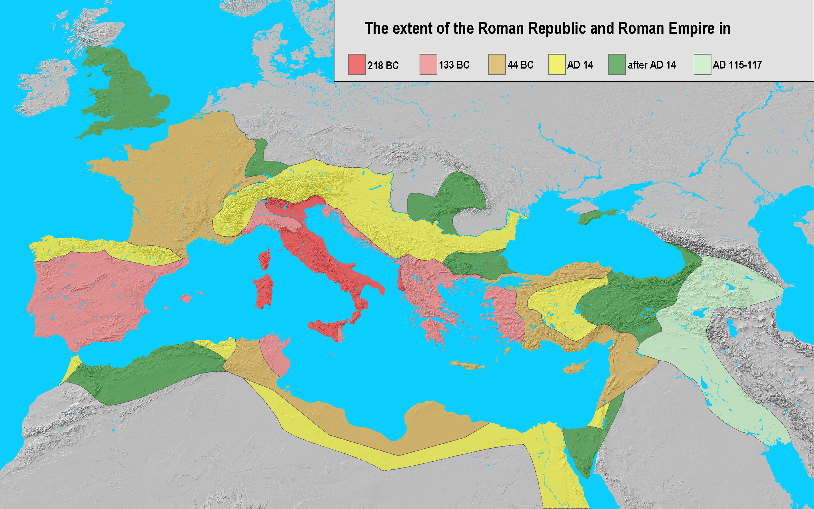
The Extent of the Roman Republic and Roman Empire 218 BC, 133 BC, 44BC, AD 14, after AD 14 AD 115-117.
Courtesy of Wikimedia.
The Roman Conquest of Italy 500 BC-237 BC.
Interactive map excerpted from the Historical Atlas of the Mediterranean courtesy of Gareth Mann.
Roman Conquest of Italy to the end of the 2nd Punic War
Courtesy of Wikimedia.
Expansion of Roman Republic
Before 300 BC-44 BC. Courtesy of the History of the English Podcast.
Epirus and Rome
Courtesy of the Total War Center.
Map depicting the campaigns of Pyrrhus in southern Italy and Sicily and the location of Epirus in Greece.
Courtesy of Wikipedia.
Map of Roman Roads in Italy
Courtesy of Wikipedia.
The Mediterranean World: During the Decline of the Hellenistic Kingdoms and the Rise of Rome 270 B.C.,
from Tony Belmonte’s original.
Growth and decline of Carthaginian Empire
Carthaginian possesion 256 BCE, Carthaginian losses by 238 BCE, Carthaginian conquests by 218 BCE, Carthage 201 BCE end of 2nd Punic Wars. Carthage, Light Blue – Carthaginian allies, Italian cities who allied with Hannibal. Northern Italian tribes who allied with Hannibal are in blue font. Red – Rome, pink – Roman allies. Courtesy of Wikipedia.
The Roman Republic c. 264 -241 BC The First Punic War
Excerpted from Ian Mladjov’s Resources.
The Mediterranean in 218 BC (Rome and Carthage before the Second Punic War)
Excerpted from Ian Mladjov’s Resources.
The First Punic War.
Interactive map excerpted from the Historical Atlas of the Mediterranean courtesy of Gareth Mann.
Italian Peninsula and Vicinity: 2nd Punic War
Principal Areas up to the 3nd Punic war 218 BC. Courtesy of Emerson Kent.com: World History for the Relaxed Historian.
Principal Areas in Italy and the Mediterranean, 218 B. C.
Courtesy of the Patriot Files.
The Mediterranean in 218 BC (Rome and Carthage before the Second Punic War)
Excerpted from Ian Mladjov’s Resources.
The Western Mediterranean prior to the 2nd Punic Wars.
Courtesy of Wikipedia.
The Second Punic War
Interactive map excerpted from the Historical Atlas of the Mediterranean courtesy of Gareth Mann.
Hannibal in Italy: Overview
Courtesy of The Department of History at the United States Military Academy.
Greece and its Vicinity 200 BC: Second Macedonian War
Courtesy of The Department of History at the United States Military Academy.
Roman Republic, 200 BC
The Republic in the context of the polities of Eurasia. Courtesy of Wikimedia.
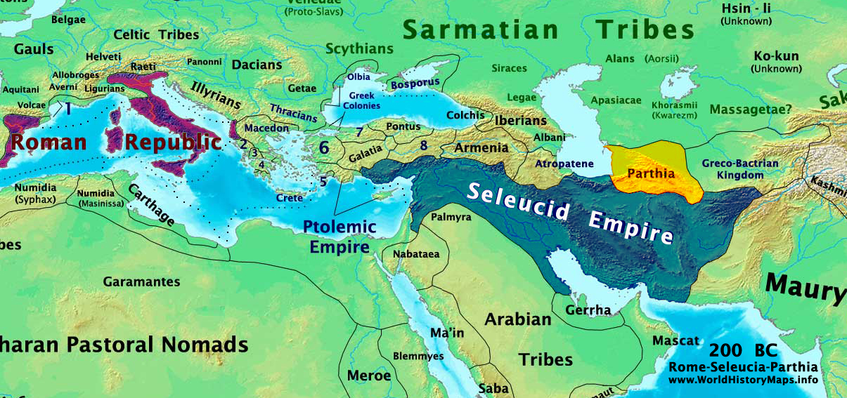
Rome-Seluecid-Parthia 200 BC
Excerpted from Talessman’s Atlas.
The Roman Conquest of the Mediterranean
330 BC, 260 BC, 220 BC, 200 BC, 130 BC, 50 BC, 20 AD, 70 AD. Interactive map excerpted from the Historical Atlas of the Mediterranean courtesy of Gareth Mann.
Kingdom of Pontus: 281 BCE-62CE
The Kingdom of Pontus at its height: before the reign of Mirthridates VI (dark purple), after his early conquests (purple), and his conquests in the First Mithridatic wars (pink). Client of the Roman Republic and Roman Empire (66 BC-62 AD). Courtesy of Wikipedia.
The Roman Republic in the years 131-129 BC: creation of the first Asia Asian province.
Courtesy of Wikimedia Commons.
Roman Republic in the Near East in 127 B.C.
Courtesy of Wikimedia Commons
Roman World: Urbanization in 2nd Cent. CE
Excerpted from Osshe Historical & Cultural Atlas Resource.
Major Temples and Sanctuaries
Excerpted from Osshe Historical &Cultural Atlas Resource.
Expansion of Rome about the 2nd Century B C.
Courtesy of The Department of History at the United States Military Academy.
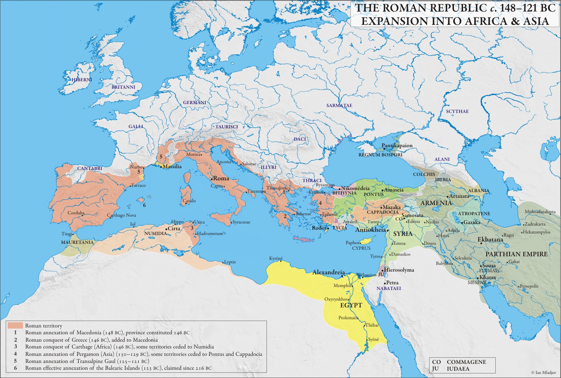
The Mediterranean c, 148-121 BC (Roman expansion into Africa and Asia)
Excerpted from Ian Mladjov’s Resources
Asia Minor c. 120 BC
Excerpted from Ian Mladjov’s Resources.
The Roman Republic in the Near East in 102/101 B.C., making the second Asian province: Cilicia.
Courtesy of Wikimedia Commons.
The Roman Republic in the Near East in 92 B.C., when L.Cornelius Sulla was praetor of Cilicia
Courtesy of Wikimedia Commons.
Roman Africa
100 BC, 50 AD, 200 AD, 285 AD. Interactive map excerpted from the Historical Atlas of the Mediterranean courtesy of Gareth Mann.
Numidia 112-105 B.C.: The Jugurthine War.
Courtesy of The Department of History at the United States Military Academy.
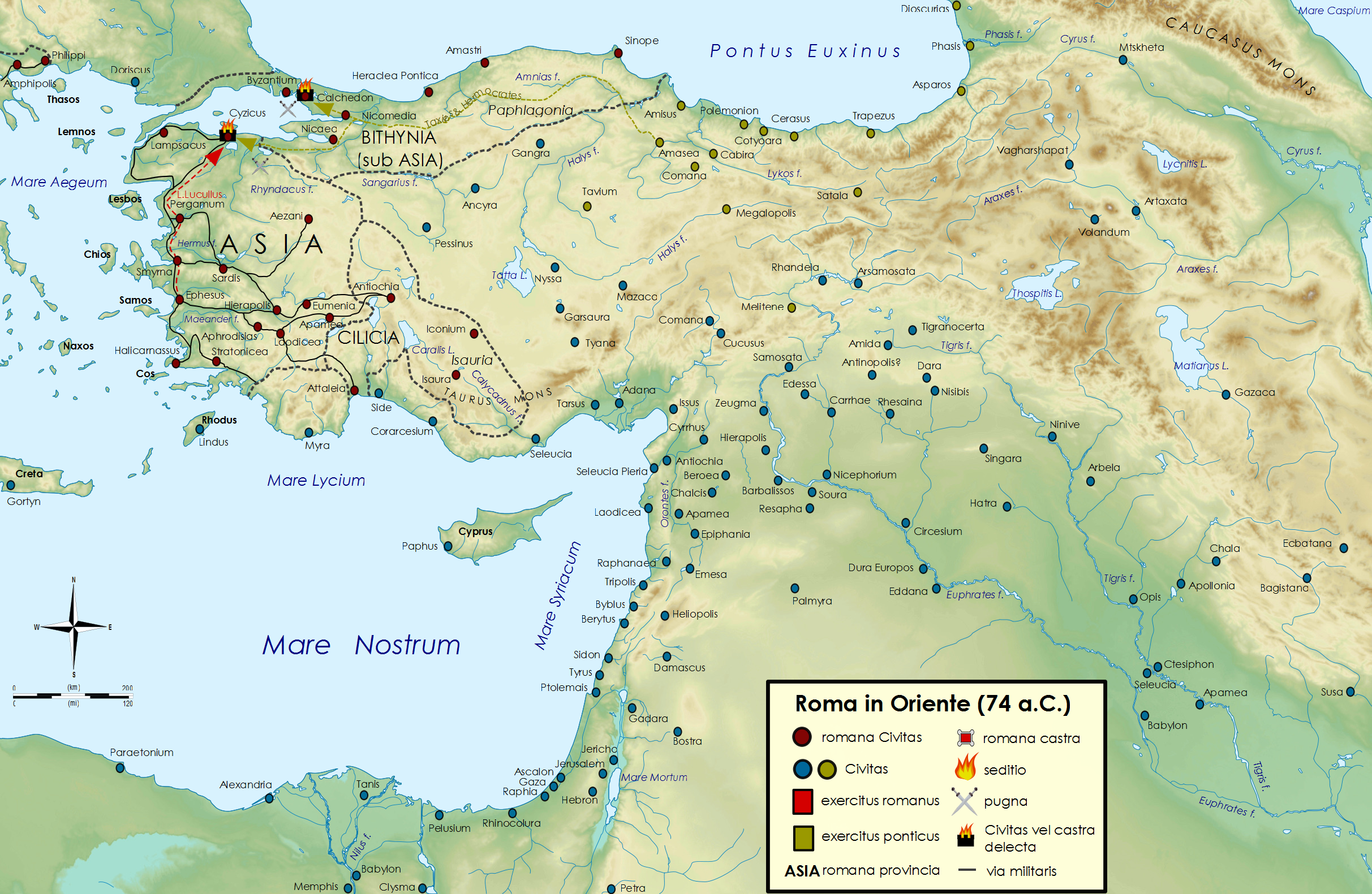
The three Roman Wars against Mithridates VI (89-85, 83/82, 74-63 BC)
Courtesy of Prezi.
Map of the First Year of the first Mithradatic War (89 BC)
Courtesy of Wikimedia Commons.
The Roman Republic in the East in 88 BC, during the second year of the first Mithridatic war
Courtesy of Wikimedia Commons.
The crucial years (87-86 BC) of the First Mithridatic War
Courtesy of Wikimedia Commons.
Asia Minor c. 85 BC.
Excerpted from Ian Mladjov’s Resources
Map of the First Year of the third Mithradatic War
Courtesy of Wikimedia Commons.
The Roman Republic in the East in 73-71 BC, during the Third Mithridatic War .
Courtesy of Wikimedia Commons.
The years 70-69 BC of the Third Mithridatic War
Courtesy of Wikimedia Commons.
The year 68 BC the Third Mithridatic War
Courtesy of Wikimedia Commons.
Roman Republic in the Near East in 67 B.C., during the third Mithridatic War
Courtesy of Wikimedia Commons.
Rome’s Wars in Italy and Abroad, 78-63 BC
“This map depicts the landscape of Mediterranean world during the early part of the first century BC, from the Iberian Peninsula and Mauretania in the west to Armenia, the Euphrates frontier and the Red Seain the east. The map also portrays select sites relating to the history of Rome. This map was prepared to accompany the book The Romans from Village to Empire by Mary T. Boatwright, Daniel Gargola and Richard J.A. Talbert, Oxford University Press, 2004, where it appears as Map 7.2.”.
Asia Minor c. 63 BC.
Excerpted from Ian Mladjov’s Resources.
Rome’s Empire in 60 B.C.
“This map depicts the landscape of Mediterranean world in 60 B.C. and labels those regions that formed part of Rome’s empire by that date. This map was prepared to accompany the book The Romans from Village to Empire by Mary T. Boatwright, Daniel Gargola and Richard J.A. Talbert, Oxford University Press, 2004, where it appears as Map 8.1.”.
Roman Hispania
56 BC, 10 AD, 285 AD. Interactive map excerpted from the Historical Atlas of the Mediterranean courtesy of Gareth Mann.
Spain: Urbanization
Excerpted from Osshe Historical & Cultural Atlas Resource.
Maps of the Roman World in the First Century C.E.
Copyright ©1996 CenturyOne Bookstore. All Rights Reserved.
The Mediterranean in 59 BC (before the First Triumvirate)
Excerpted from Ian Mladjov’s Resources.
The Roman Republic c. 60-53 BC During the First Triumvirate
Excerpted from Ian Mladjov’s Resources.
The Demise of the Roman Republic (50 BC-30 BC)
Interactive map excerpted from the Historical Atlas of the Mediterranean courtesy of Gareth Mann.
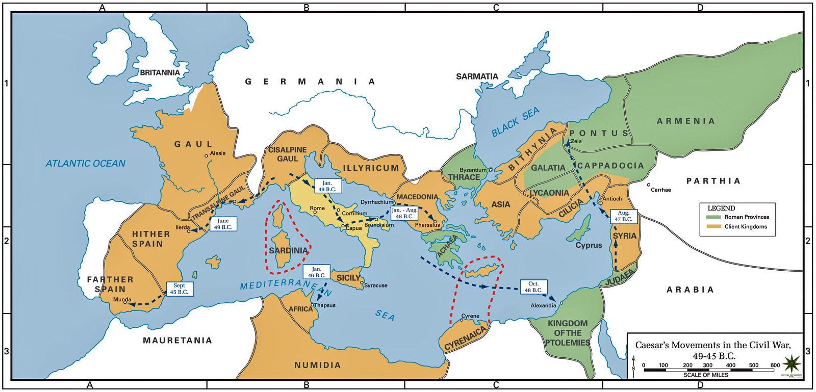
Caesar’s Movements in the Civil War 49-45 B.C.
Courtesy of Emerson Kent.com: World History for the Relaxed Historian.
The Roman Republic-The Civil Wars (49-30 BC)
Courtesy of DeviantArt
Europe and its vicinity 44 B.C. Roman Republic at the Time of Caesar
Courtesy of The Department of History at the United States Military Academy.
Roman Campaigns, 44-30 BC
“This map depicts the landscape of southern Europe, northern Africa and south-western Asia during the first century B.C., from Nearer Spain and Transalpine Gaul in the northwest to the Red Sea and the mouth of the Euphrates in the southeast. Sites and regions relevant to Roman military campaigns between 44 and 30 B.C. are labeled. Excerpted from the Ancient World Mapping Center”.
The Roman Republic c. 49-44 BC under Caesar’s Supremacy
Excerpted from Ian Mladjov’s Resources.
The Roman Empire, 44 BCE-117 CE
Courtesy of Geoawesomeness.
The Roman Republic in 43 BC after the establishment of the Second Triumvirate.
Courtesy of Wikipedia
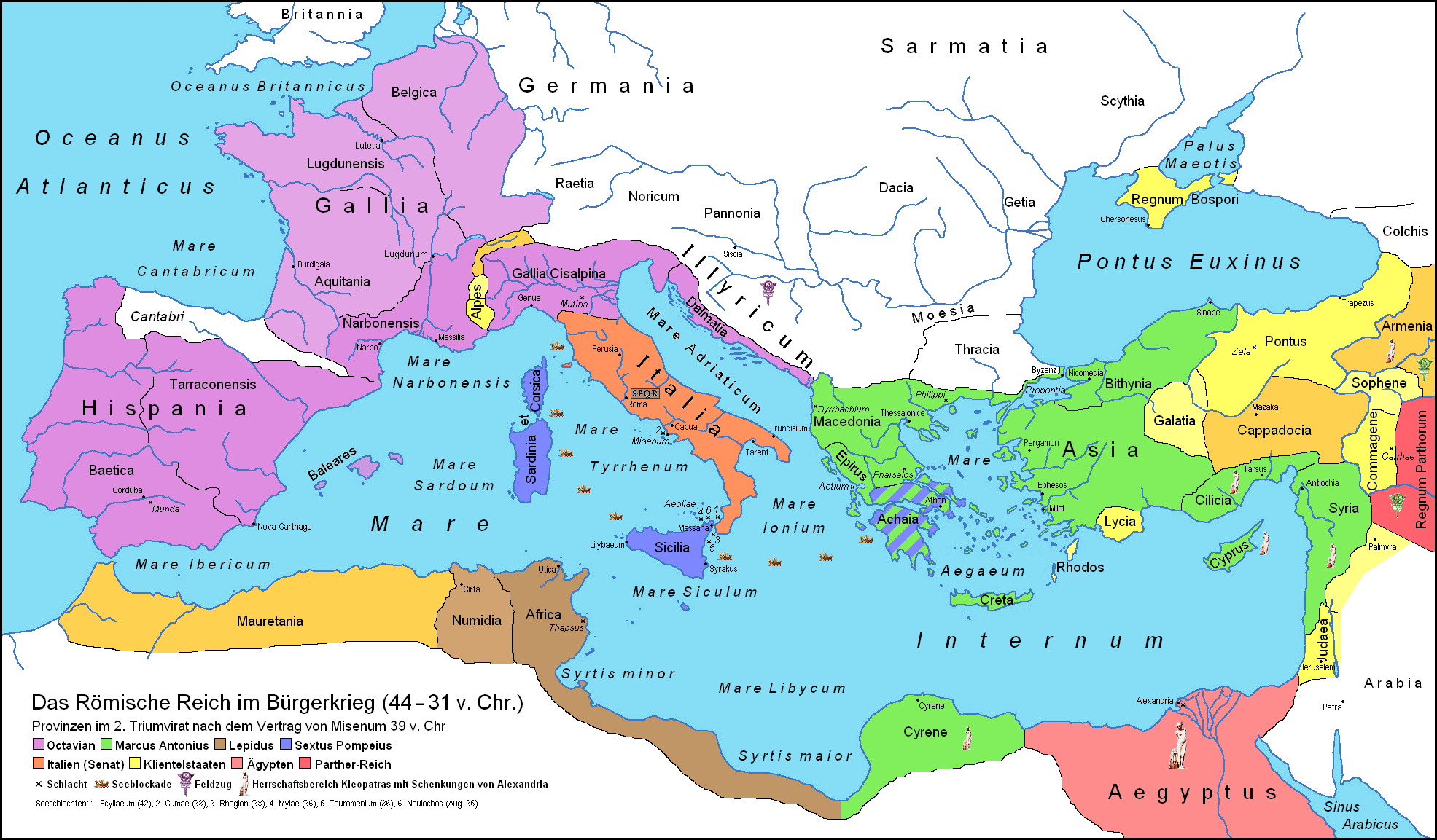
The Roman Republic c. 43-33 BC During the Second Triumvirate
Excerpted from Ian Mladjov’s Resources.
Map of the Roman Republic in 42 BC after the Battle of Philippi.
Courtesy of Wikipedia
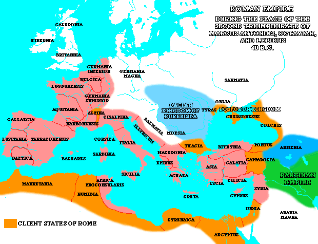
The Roman Empire: During the Peace of the Second Triumphurate, 40 B.C
from Tony Belmonte’s original.
The Roman Republic in 39 BC after the Treaty of Brundisium and the Treaty of Misenum
Courtesy of Wikipedia
The Donations of Alexandria in 34 BC.(by Mark Antony to Cleopatra and her children) in 34 BC.
Courtesy of Wikipedia
Settlement of Veterans in Italy by Julius Caesar and Augustus.
“This map depicts the landscape of Roman Italy, from Augusta Praetoria and Tergeste in the north to Nuceria and Venusia in the south, together with those sites at which Julius Caesar and Augustus settled military veterans. This map was prepared to accompany the book The Romans from Village to Empire by Mary T. Boatwright, Daniel Gargola and Richard J.A. Talbert, Oxford University Press, 2004, where it appears as Map 8.3.”
Asia Minor c. 31 BC.
Excerpted from Ian Mladjov’s Resources
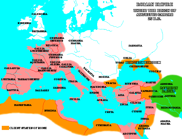
The Roman Empire under the reign of Augustus Caesar 25 B. C.
from Tony Belmonte’s original.
Roman Provence
Gallia Narbonensis (20 B C). Interactive map excerpted from the Historical Atlas of the Mediterranean courtesy of Gareth Mann.
Interactive Map of the Roman Empire and Celtic Lands
Excerpted from the Celts and Romans in Britain.
Map of New Testament Israel (1st century AD)
Excerpted from Bible History Online.
Map of Armenia and the Roman client states in eastern Asia Minor, ca. 50 AD
Before the Roman-Parthian War and the annexation of the client kingdoms into the Empire. : Image Source : Wiki Commons.
Iran Historical Maps: Arsacid Parthian Empire, Armenian Kingdom
Collection of Twenty one maps, including maps detailing Roman campaigns in Armenia and Parthia.
Roman-Persian Frontier in Late Antiquity
From Wikipedia, the free encyclopedia.
The Military campaigns of Nero Claudius Drusus Germanicus in Germania
Courtesy of Biblitheca Germania.
Roman campaigns in Germania 15 BC.
Courtesy of Wikipedia.
Map of Drusus’campaigns against the Germanic tribes, 12-9 BC
Courtesy of Wikipedia.
The campaigns of Nero Claudius Drusus Germanicus in Germania 12-9 BC.
Courtesy of Wikipedia.
Roman Military bases in Germania during the time of Augustus and Tiberius
Courtesy of Biblitheca Germania.
The campaigns of Tiberius, Ahenobarbus, and Saturninus in Germania circa 3 BCE and 1 CE
Courtesy of Wikipedia.
The Province of Germania during the Governorship of Publius Quintilius Varus 7-9 AD
Courtesy of Wikipedia.
Roman Campaigns in Germany 1n 14 CE
Courtesy of Wikipedia.
Roman Campaigns in Germany 1n 15 CE
Courtesy of Wikipedia.
Roman Campaigns in Germany 1n 16 CE
Courtesy of Wikipedia.
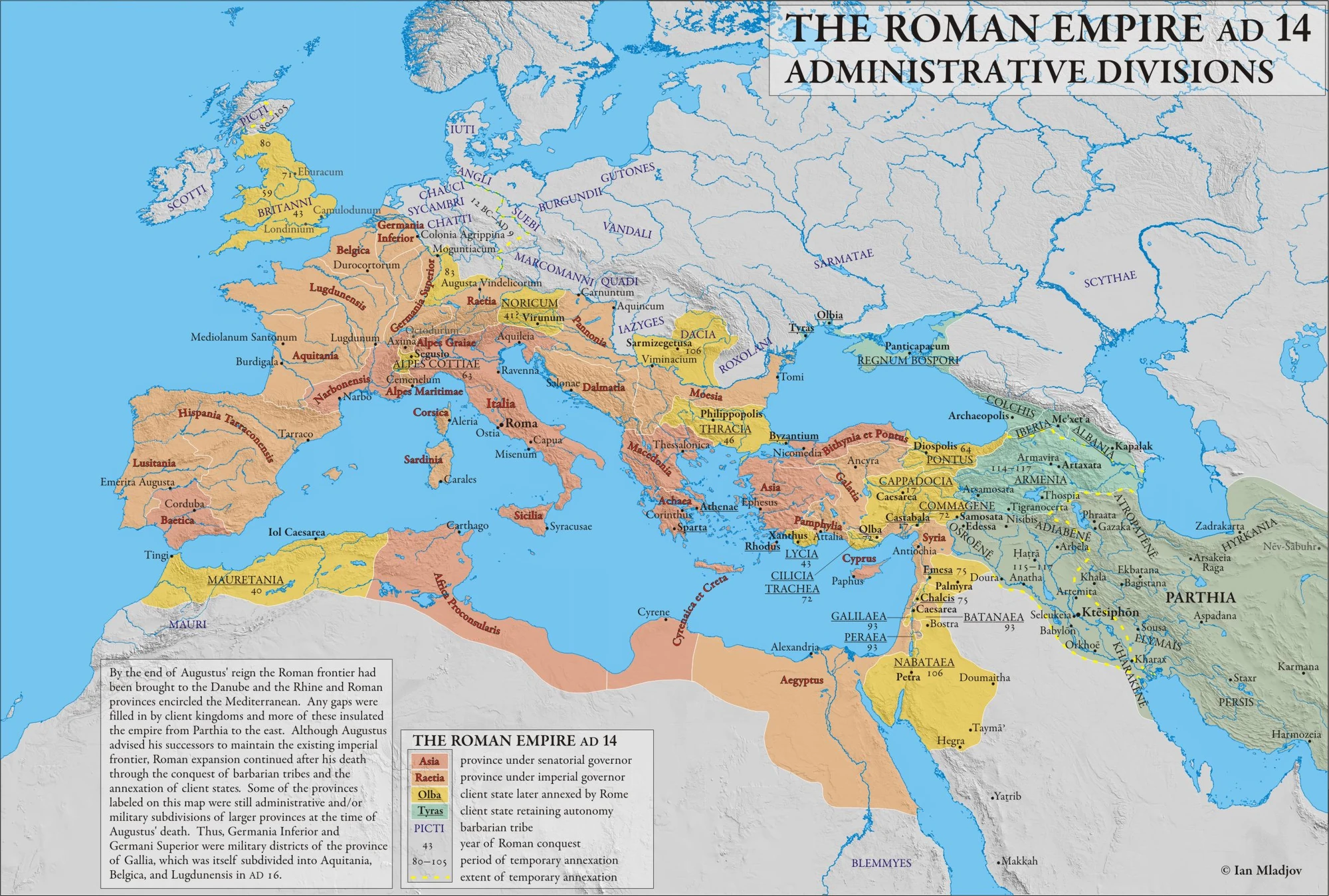
The Mediterranean in AD 14 (Roman provinces at the death of Augustus)
Excerpted from Ian Mladjov’s Resources.
The Roman Empire, A.D. 12
Courtesy of Antiquity Online.
Expansion of the Empire in the age of Augustus
“This map depicts the landscape of the Roman Empire and its surroundings in the early first century A.D., from Britannia in the northwest to Kush in the southeast. Provinces and regions at this period are labeled. This map was prepared to accompany the book The Romans from Village to Empire by Mary T. Boatwright, Daniel Gargola and Richard J.A. Talbert, Oxford University Press, 2004, where it appears as Map 9.2.”
Limes Tripolitanus.
The Limes Tripolitanus was a frontier zone of defence of the Roman Empire, built in the south of what is now Tunisia and the northwest of Libya. It was primarily intended as a protection for the tripolitanian cities of Leptis Magna, Sabratha and Oea in Roman Libya. Courtesy of Wikipedia.
Main Roman Roads in North Africa.
Courtesy of Wikipedia.
The First Jewish Revolt
Courtesy of Maps, Charts, Graphs & Reconstructions of Roman History
The Roman Conquest of Wales
Based on Frere’s Britannia, Jones’ & Mattingly’s Atlas of Roman Britain , and The Agricola by Tacitus. Courtesy of Wikipedia.
Roman Britain Military Organization (68 AD)
Based on Frere’s Britannia, Jones’ & Mattingly’s Atlas of Roman Britain , and The Agricola by Tacitus. Courtesy of Wikipedia.
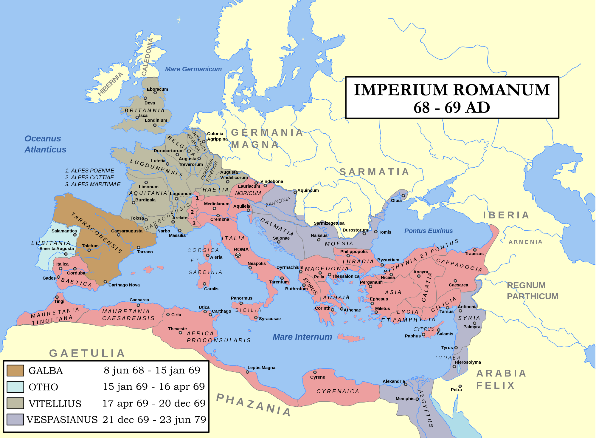
Roman Empire in A.D. 69
“This map depicts the landscape of the Roman Empire as it was in AD 69, from Britannia in the northwest to Egypt in the southeast. Provinces, principal settlements and legionary bases are labeled. This map was prepared to accompany the book The Romans from Village to Empire by Mary T. Boatwright, Daniel Gargola and Richard J.A. Talbert, Oxford University Press, 2004, where it appears as Map 10.1.”
Imperium Romanum
Excerpted from the Ancient History Encyclopedia.
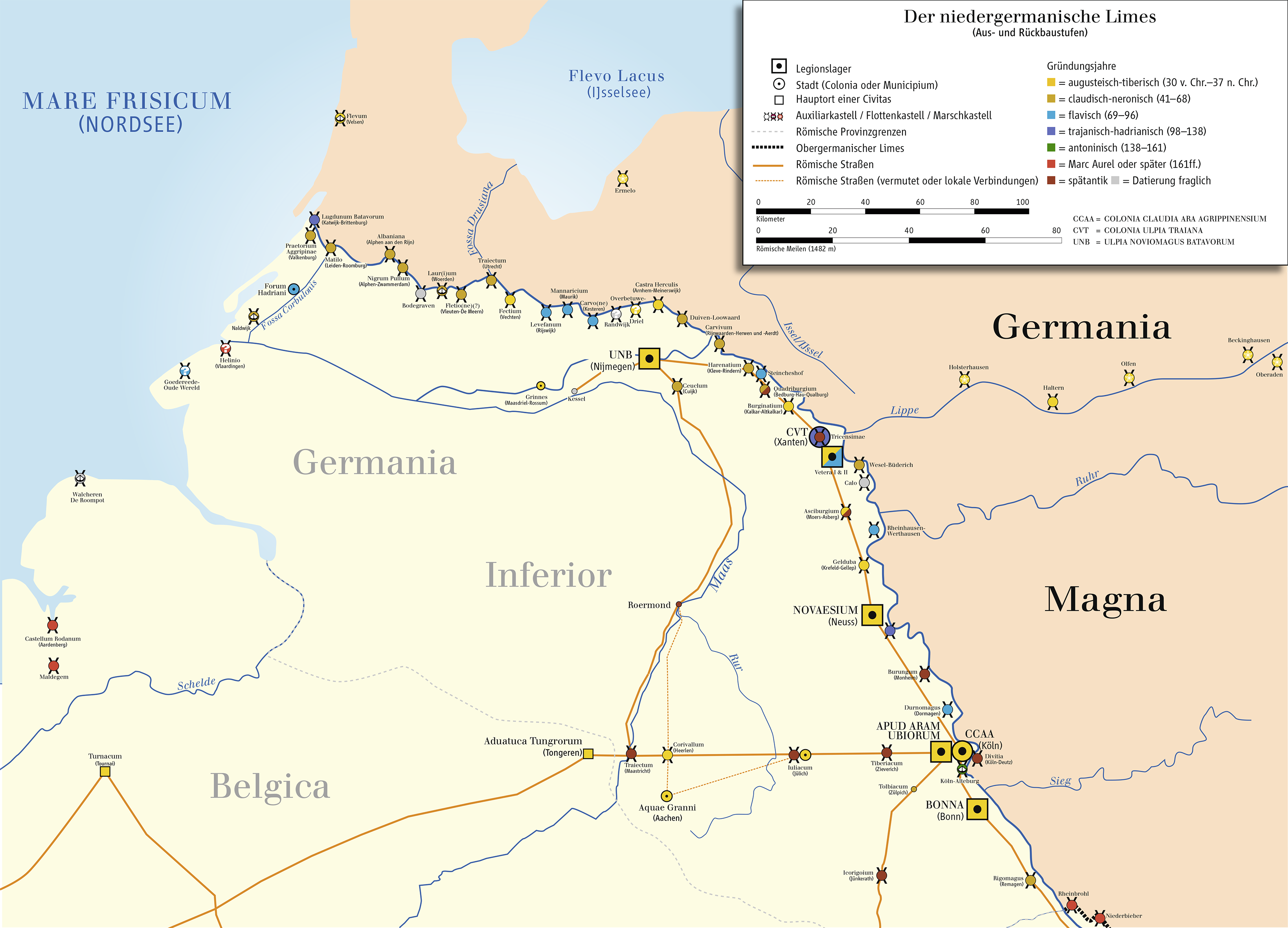
Lower Germanic Limes.
Courtesy of Wikipedia. In German.
Upper Germanic and Raetian Limes .
Courtesy of Wikipedia. In German.
Rhine Frontier of the Roman empire (70 AD)
Excerpted from the Ancient History Encyclopedia.
Pannonian Limes .
Courtesy of Wikipedia. In German.
The Jewish Diaspora: in the 1st cent. CE
Excerpted from Osshe Historical & Cultural Atlas Resource.
Agricola’s Campaigns in Britain 78-84
Excerpted from the Ancient History Encyclopedia.
Roman Britain (80-84) Northern Campaigns: Based on Frere’s Britannia
Courtesy of Academic Dictionaries and Encyclopedias.
Roman Britain Military Organization in the North (84).
Based on Frere’s Britannia. Courtesy of Wikimedia.
Rome’s Northern Provinces around A. D. 100.
“This map depicts the landscape of the northwestern portion of the Roman Empire at the end of the first century A.D., from Mauretania in the southwest to Moesia and Dacia in the northeast and Britannia in the northwest. This map was prepared to accompany the book The Romans from Village to Empire by Mary T. Boatwright, Daniel Gargola and Richard J.A. Talbert, Oxford University Press, 2004, where it appears as Map 11.1.”
Rome’s Foreign Wars, 113-82 AD
“This map depicts the landscape of the Mediterranean world during the latter second and early first centuries BC, from Further Spain and Mauretania in the west to Pontus, Syria and Egypt in the east. The map also portrays select sites relating to the history of Rome. This map was prepared to accompany the book The Romans from Village to Empire by Mary T. Boatwright, Daniel Gargola and Richard J.A. Talbert, Oxford University Press, 2004, where it appears as Map 6.1.”
Eastern Expansion of the Roman Empire in the Early 2nd Century A. D.
“This map depicts the landscape of the southeastern portion of the Roman Empire the Early Second Century A.D., from Macedonia, Achaia and Cyrenaica in the west to the Parthian Empire (including Persepolis and the Persian Gulf) in the east. This map was prepared to accompany the book The Romans from Village to Empire by Mary T. Boatwright, Daniel Gargola and Richard J.A. Talbert, Oxford University Press, 2004, where it appears as Map 11.2.”
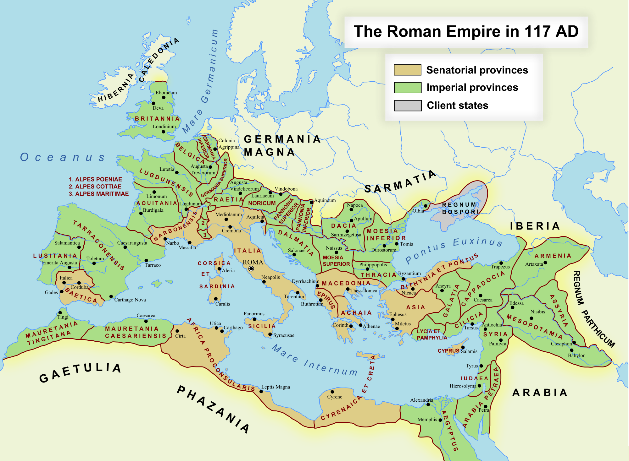
The Roman Empire at the Time of Hadrian 116 A.D.
Courtesy of Emerson Kent.com.
The Mediterranean in 117 (the death of Trajan)
Excerpted from Ian Mladjov’s Resources.
The expansion of the Roman Empire to AD 117
By Undevicesimus. Courtesy of Deviant Art.
Anatolia, western Caucasus and northern Levant under Trajan
Courtesy of Wikipedia.
The Roman Empire in 117 AD (the death of Trajan)
Displaying both Imperial and Senatorial provinces. Excerpted from the Ancient History Encyclopedia.
The Roman East 118 AD
Excerpted from Ian Mladjov’s Resources.
Roman Dacia
Courtesy of Ancient History Encylopedia.
Map of Roman Dacia
Excerpted from Apulum’s Archaeology Blog.
The Limes in Britain, 122 A.D.
Courtesy of The Patriot Files.
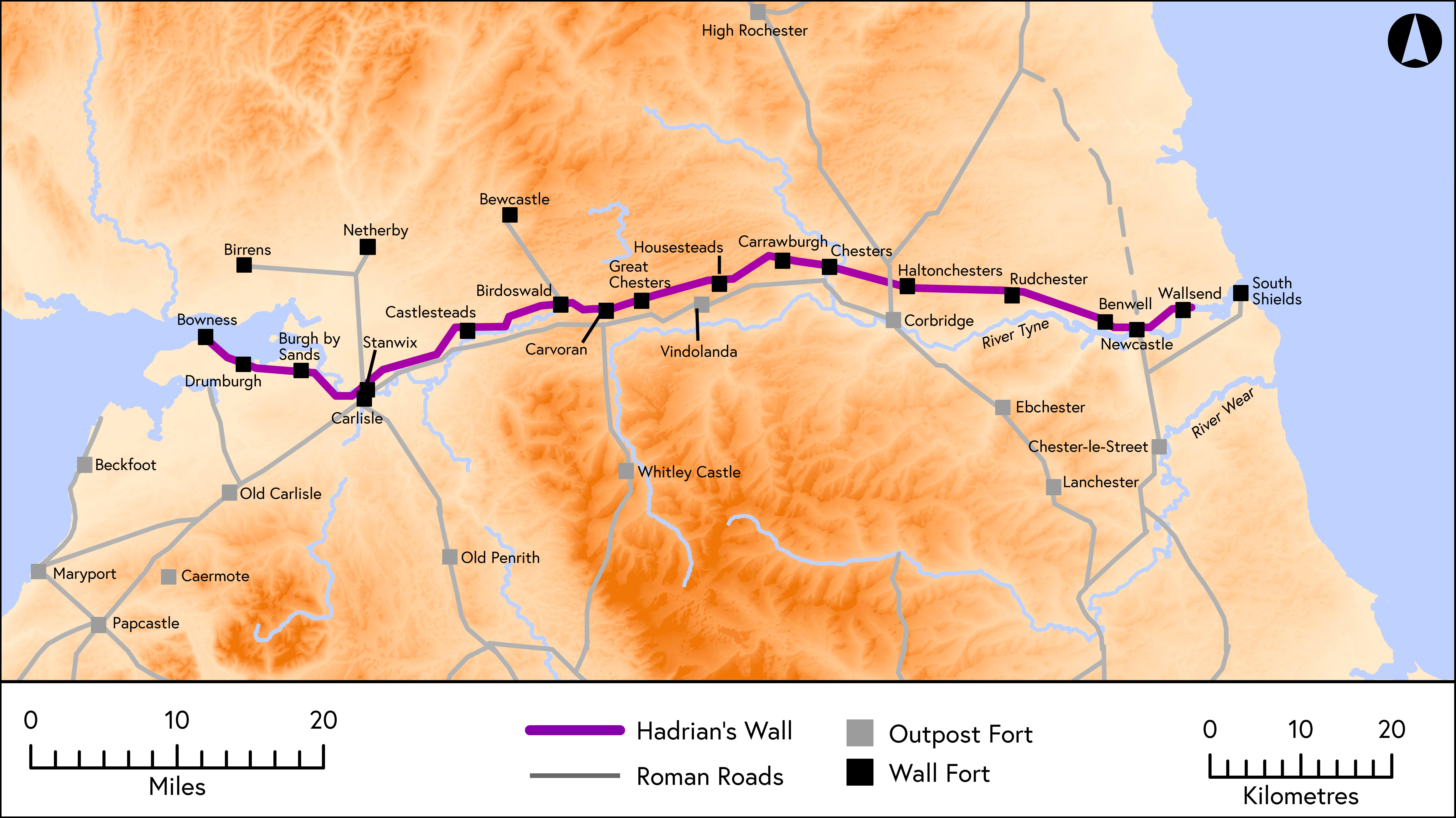
Hadrian’ s Wall.
The route of the Wall © Newcastle University.
The Limes in Germany, 2nd Century A.D.
Courtesy of The Patriot Files.
Map showing location of the Rhaetian and Upper Germanic Limes
Courtesy of Wikipedia.
The Roman Empire in AD 125
Excerpted from Academic Dictionaries and Encyclopedias.
The Roman Empire under Hadrian AD 125
By Undevicesimus. Courtesy of Deviant Art.
Roman Britain Military Organization in the North (130 AD)
Based on Frere’s Britannia. Courtesy of Wikipedia.
The Roman Empire, A.D. 150
Courtesy of Antiquity Online.
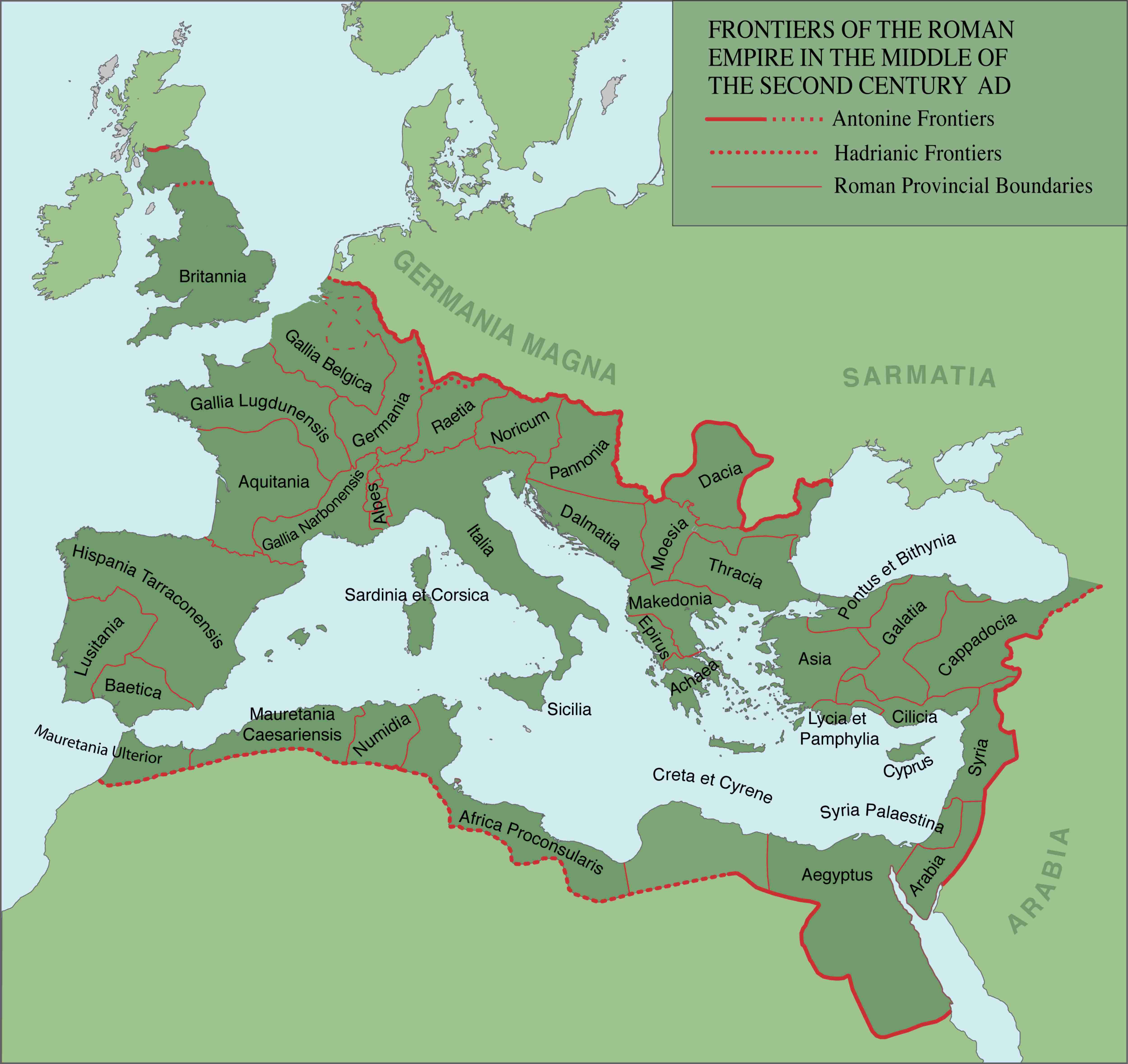
Frontiers of the Roman Empire in the Middle of the Second Century AD.
Hadrianic and Antonine Frontiers as well as Roman provincial boundaries.
Roman Britain Military Organization in the North (155).
Based on Frere’s Britannia. Courtesy of Wikipedia.
Map of all the territories once occupied by the Roman Empire, along with locations of limes
Courtesy of Wikipedia.
Campaigns of Marcus Aurelius and the Severan Emperors
“This map depicts the landscape of the Roman Empire as it was in the late second to early third centuries A.D. Provinces, principal settlements and legionary bases are labeled. This map was prepared to accompany the book The Romans from Village to Empire by Mary T. Boatwright, Daniel Gargola and Richard J.A. Talbert, Oxford University Press, 2004, where it appears as Map 12.1.”
The Roman Empire in 180 AD
Map of empire showing provincial boundaries.
Provinces of the Roman Empire AD 180
Excerpted from Ian Mladjov’s Resources.
Roman Britain Military Organization in the north (180)
Based on Frere’s Britannia. Courtesy of Wikimedia.
Theaters outside the Greek and Roman Homelands ca. 200 CE
Excerpted from Osshe Historical &Cultural Atlas Resource.
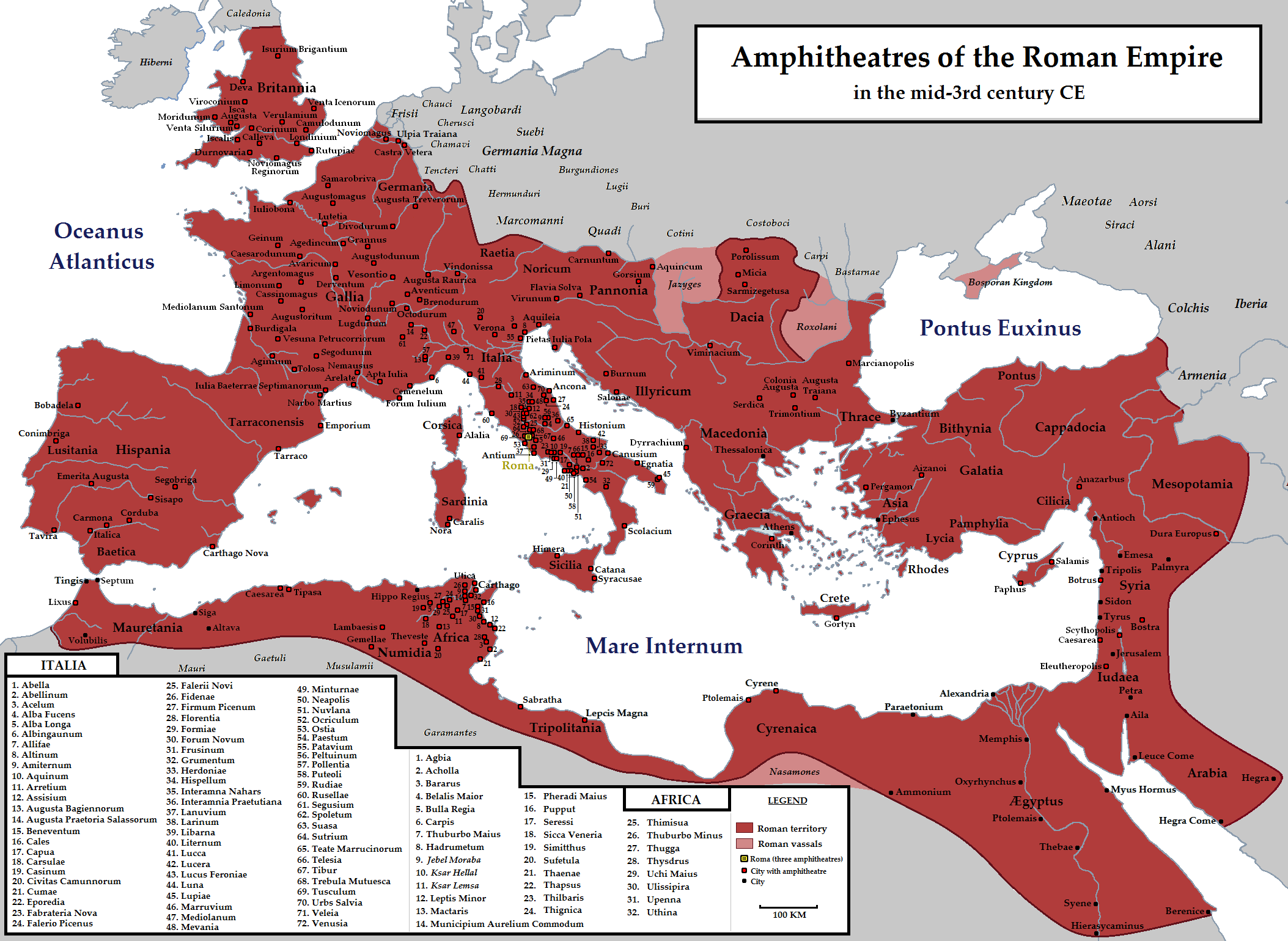
Amphitheaters of the Roman Empire in the mid-3rd century CE.
Courtesy of Wikipedia.
Septimus Severus’ African conquests
“The frontier of Roman Africa (dark tan) in the late 2nd century AD. Septimius Severus expanded the Limes Tripolitanus dramatically (medium tan), even briefly holding a military presence (light tan) in the Garamantian capital Garama in 203. Much of the initial campaigning success was achieved by the legate of Legio III Augusta, Quintus Anicius Faustus.” Courtesy of Wikimedia.
Provinciae Imperii Romanorum AD 210
Courtesy of The History Notes
Roman Britain Northern Campaigns (208-211)
Based on Frere’s Britannia. Courtesy of Wikimedia.
The Roman Empire in A.D. 211
Excerpted from Ian Mladjov’s Resources.
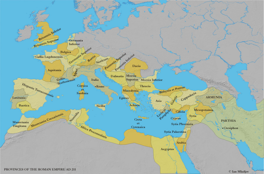
The Rome Legions at the End of Septimus Severus’s Rule: Circa 211 A.D.
Courtesy of wikimedia.org
Imperial Rome 211 A. D.
Courtesy of mapmania.org
Roman Maps Project
Roman Empire: 3rd century Anno Domini 9th century Anno Urbis Conditae. ©1996 Dave Weber, WMW Reprographics Ltd.
Roman Empire 230 AD Administrative Divisions
Excerpted from Ian Mladjov’s Resources.
The Roman Empire’s North and West in the ‘Age of Crisis
“This map depicts the landscape of the northwestern Roman Empire during the mid-third century A.D., from Eburacum in the northwest to Athens in the southeast. This map was prepared to accompany the book The Romans from Village to Empire by Mary T. Boatwright, Daniel Gargola and Richard J.A. Talbert, Oxford University Press, 2004, where it appears as Map 13.1.”
The Palmrene Empire 270-273 AD
Courtesy of Wikimedia.
The Mediterranean in 271 AD ( the Crisis of the Third Century)
Excerpted from Ian Mladjov’s Resources.
The Roman Empire by 271 A.D before the reconquest of Palymerene and Gallic empires by Aurelian.
Courtesy of Wikipedia.
Roman Empire of Diocletian and Constantine
“This map depicts the dioceses and provinces of the Roman Empire following the restructuring of Diocletian. Principal settlements of the period are also labeled. This map was prepared to accompany the bookThe Romans from Village to Empire by Mary T. Boatwright, Daniel Gargola and Richard J.A. Talbert, Oxford University Press, 2004, where it appears as Map 13.2.”
The Tetrarchy 293- 305
Excerpted from Ian Mladjov’s Resources.
Map of the Roman Empire during the First tetrarchy
Courtesy of Wikimedia.
The Roman Empire Dioceses c. 305
Excerpted from Ian Mladjov’s Resources
The Tetrarchy 305- 306
Excerpted from Ian Mladjov’s Resources
The Tetrarchy 311- 312
Excerpted from Ian Mladjov’s Resources
Map of Roma (AD 312)
Excerpted from Ian Mladjov’s Resources
The Roman Empire 317-324 AD
Excerpted from smerdaleos
The Roman Empire 335-337 AD
Excerpted from smerdaleos
The Roman Empire 337-340 AD
Excerpted from smerdaleos
The Rise of Christianity
200 AD, 325 AD, 400 AD, 600 AD. Interactive map excerpted from the Historical Atlas of the Mediterranean courtesy of Gareth Mann.
The Roman Empire 395 Administrative Divisions
Excerpted from Ian Mladjov’s Resources.
The Mediterranean in 395 AD (Roman dioceses at the death of Theodosius I )
Excerpted from smerdaleos
The Mediterranean in 395 AD (Roman praetorian praefectures at the death of Theodosius I)
Excerpted from smerdaleos.
The Mediterranean in 395 AD (division of the Roman Empire at the death of Theodosius I )
Excerpted from smerdaleos.
Rhine Frontier of the Roman Empire (4th century AD)
Courtesy of Wikimedia.
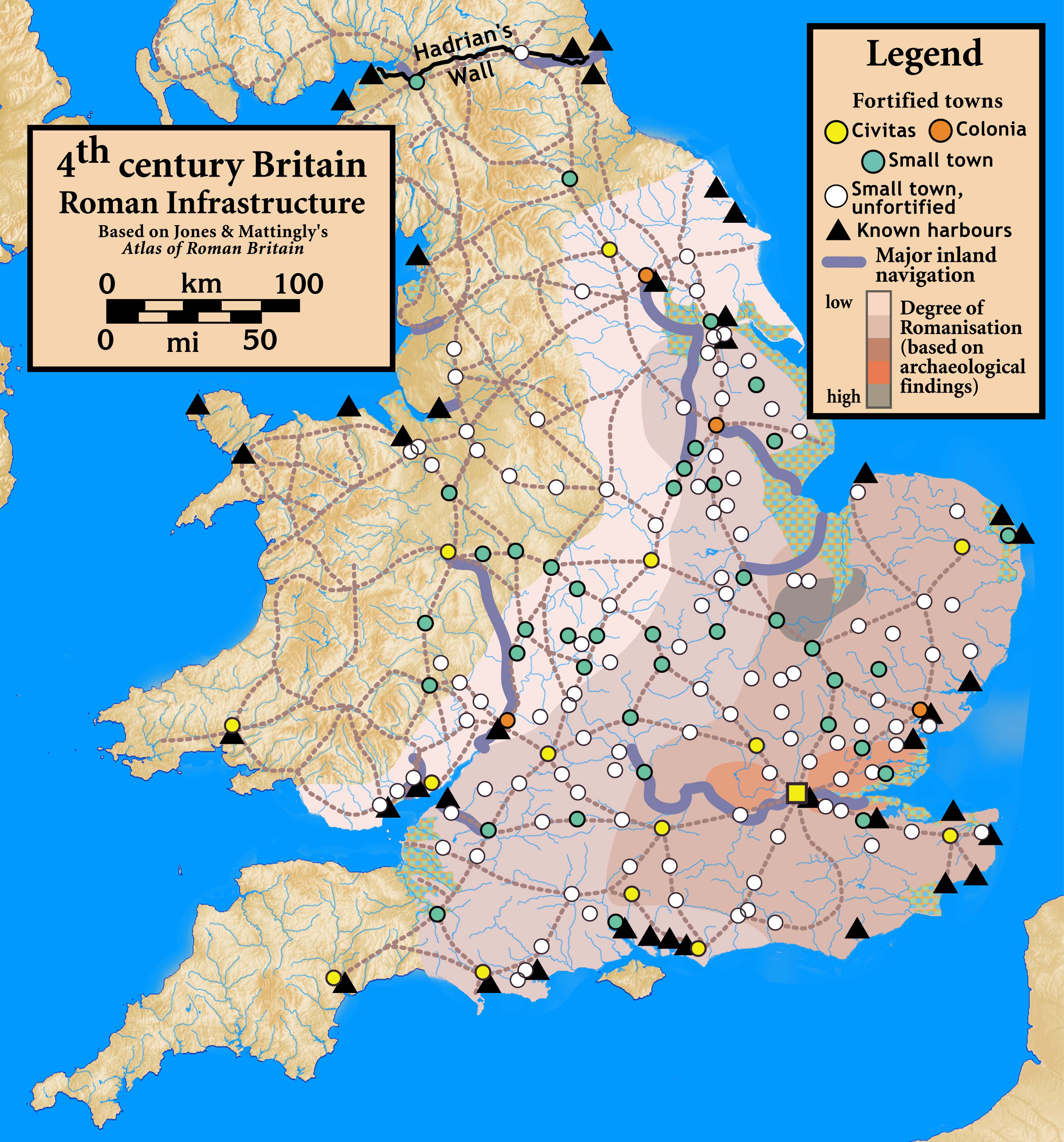
4th century Britain: Roman Infrastructure
Based in part on Ptolemy’s map and Jones & Mattingly ‘s Atlas of Roman Britain. Courtesy of Wikimedia.
Roman Northern Britain c.350-400
Based in part on Ptolemy’s map and Jones & Mattingly ‘s Atlas of Roman Britain. Courtesy of Wikimedia.
Britannia in c. 400 AD ( Roman Britain: detailed map).
Excerpted from Ian Mladjov’s Resources.
Roman-Persian Frontier in Late Antiquity
The frontier between the Roman/Byzantine and Sassanid Persian empires in Late Antiquity (4th-7th centuries).Courtesy of Wikimedia.
The Mediterranean in 415 AD (amid Barbarian Invasions
Excerpted from Ian Mladjov’s Resources.
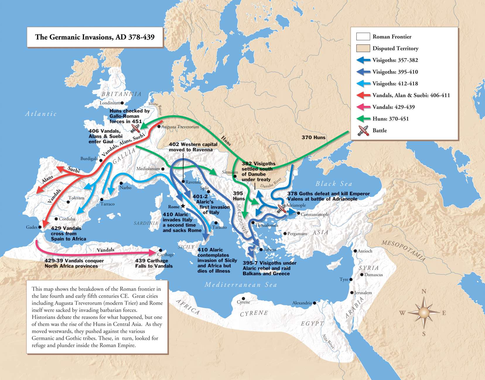
The Germanic Invasions, AD 378-439
“The map shows the breakdown of the Roman frontier in the late fourth and early fifth centuries CE.”
Barbarian Movements
Maps of the movement of the Huns, Vandals, Alans, Sueves, Ostrogoths, Visigoths, Franks, Angles, Saxon, Jutes, Scots and Britons. from 395 AD.
The Roman Empire in the 5th century AD: Routes of the Barbarian invaders
Excerpted from the Ancient History Encyclopedia
Roman Britannia about 410 AD
Excerpted from Ian maps of.net
Orthodoxy & Heresy circa 450 AD
Excerpted from Ian Mladjov’s Resources
The Campaigns of the Emperor Majorian (457-461 AD)
Excerpted from Maps on the Web
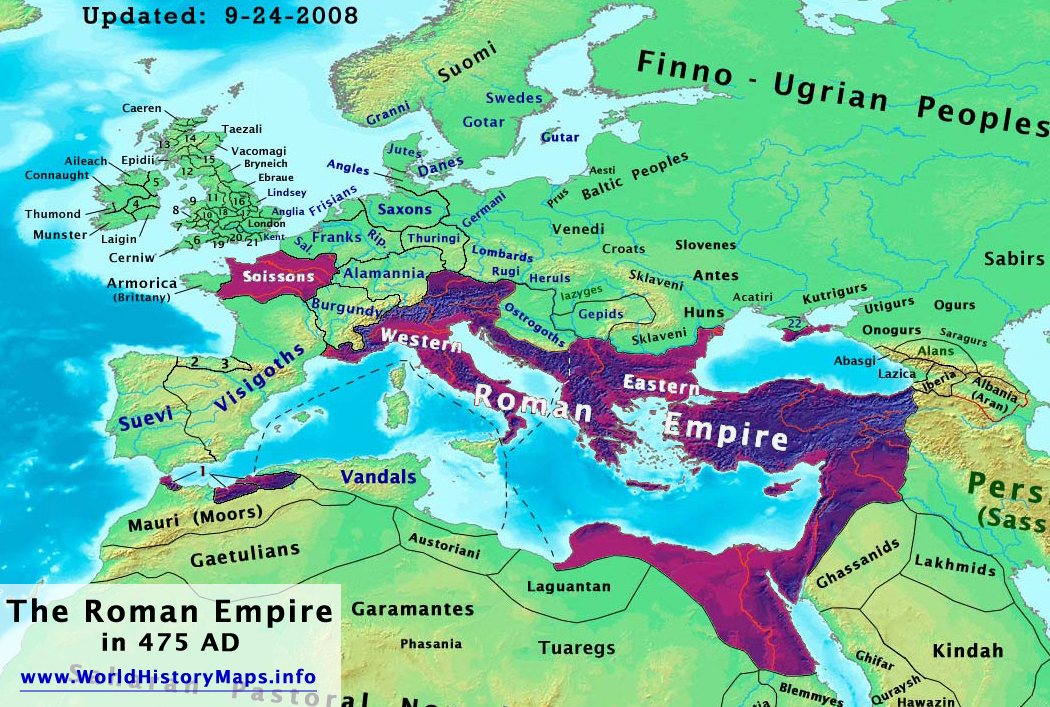
The Roman Empire in 475 AD
Excerpted from Talessman’s Atlas of World History.
The End of the Roman Empire , AD 476
By Undevicesimus. Courtesy of Deviant Art
Maps and Illustrations from Samuel b. Platner’s The Topography and Monuments of Ancient Rome
Excerpted from Ancient Rome: Images and Pictures by Felix Just, S.J., Ph.D.
Maps and Codices of the Roman Empire from the library of Trimalchio